

17 April 2004
Rogue State
“An understanding of the current crisis requires a sense of Haiti’s history,” notes Paul Farmer, situating the recent coup squarely into the long, brutal history of U.S. economic and military intervention.
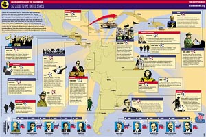
The latest Indypendent expands the story to the rest of Latin America and the Caribbean, and does so graphically with this map of U.S. military intervention in the region from 1950 through 2004. Download the PDF here.
The Indypendent, is the biweekly paper of the New York City Independent Media Center. The map is designed by ILC.iNK.
“ILC.iNK develops pages and up-to-date content specifically directed towards the Hispanic community, designed and illustrated with photographs, illustrations and infographics to captivate readers, and always customized to the general format of your publication and the needs of your advertisers. ILC.iNK is the ideal solution to develop special supplements, features, or regularly appearing sections such as Health, Sports, Children, Travel, Food, Music, etc.”