

high line
The High Line, Part 2
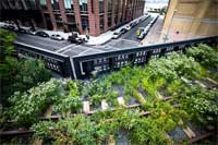
The second section of The High Line opened to the public today. Once slated for demolition, the depression-era elevated railway has been converted into a unique public park running along the west side of Manhattan. The new section extends the Line another ten blocks — nearly doubling the park’s previous length. I’ve written about the Line, the amazing grassroots campaign behind its rescue and redevelopment, and their strategic use of graphics. And though I use these graphics below in presentations about campaign communication, I’ve never posted them here.
These infographics were produced by James Corner Field Operations and used in community meetings early in the redevelopment process. The images are more impressionistic than quantitative, but they really capture a sense of the vibrant growth, use, flora and fauna projected over the first 5 years of the Line. What New Yorker wouldn’t want to be right in the middle of that cluster of flowers and birds (especially if they didn’t have to leave Manhattan?)
For the full effect, click below for higher resolution versions.
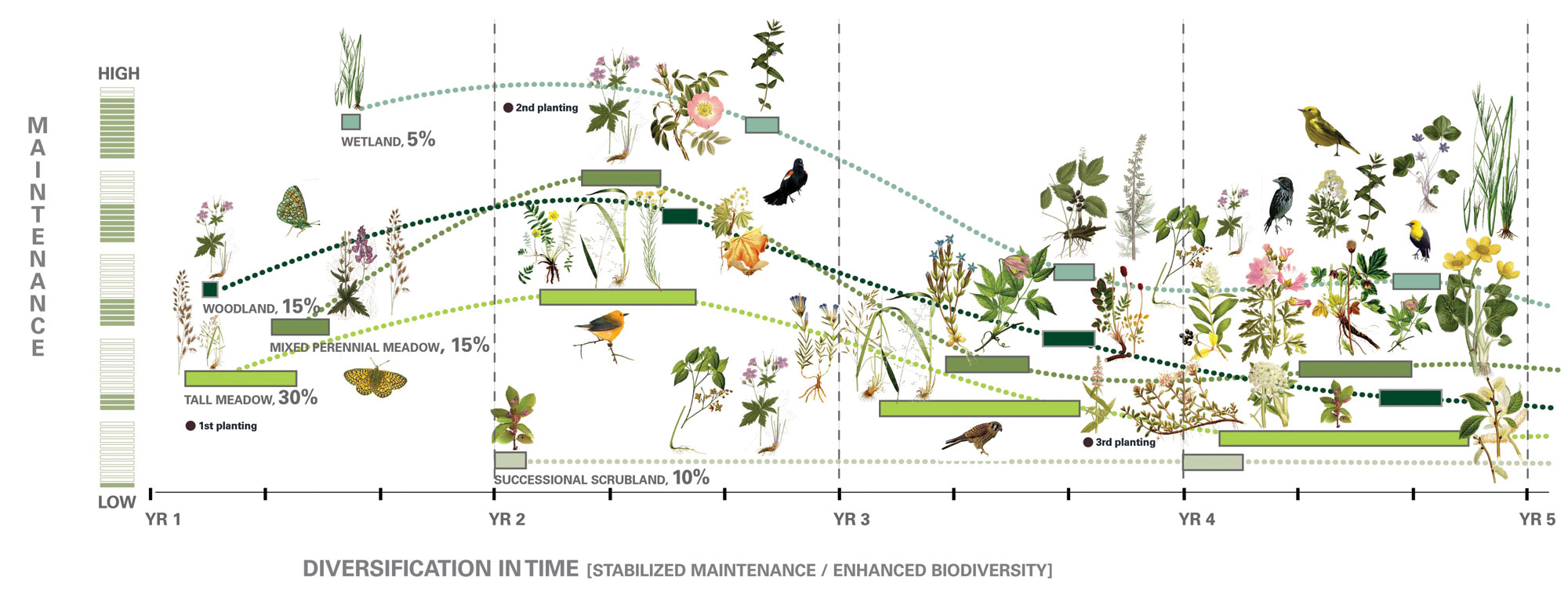
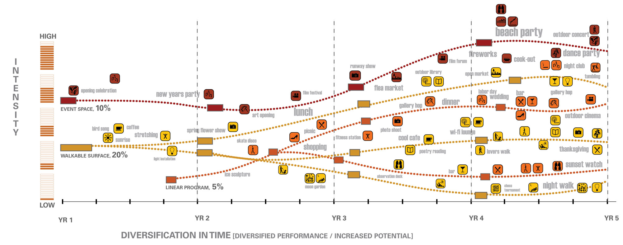
What these graphics don’t capture is the incredible economic impact of the the Line. Gentrification in the Meatpacking District was underway well before redevelopment of the Line began, but the transformation of the far west side has astonished many. But then that was perhaps a different presentation — one of the first tactical moves of the campaign to save the Line was an economic redevelopment and feasibility study. That certainly has paid off.
Designism 4.0

The Art Directors Club hosted Designism 4.0 this Wednesday night in their New York City gallery. This was the fourth annual event on design and social change there, and after last year’s ambitious program was cut short by the Vice-Presidential debate this year’s program was significantly streamlined — four slideshows, a roundtable, and one big question: how to do good work and still eat.

Mapping Power
An article I wrote is out now in the Design Issues column of the May/June 2009
Communication Arts. It draws on the material I presented at Conflux in September 2008.
Mapping Power
Using design to get where we want to go
What is power? It’s an abstract dynamic, an engine behind the visible world. Power can be found in relationships, in the flow of resources or information, in signs, symbols and ideas or built into the environment. There’s no doubt that visual media has the power to influence an audience, but visual media can also be used to visualize power itself. Visualizing power is a way of interpreting and understanding it. And this understanding can become a basis for challenging it. Design can be used to describe and locate power, to pressure those who hold power, and ultimately to facilitate and generate power by bringing people together.
High Line Architects Selected
Congratulations to James Corner Field Operations and Diller Scofidio + Renfro for their selection as architects for the redesign of the High Line.
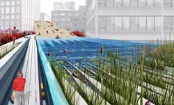 On July 15, I attended a presentation by the four finalist teams at the Center for Architecture, and it was clear that the Diller, Scofidio + Renfro team had done their research. More than any of the other teams, they had examined the relationship between the Line and the City. They presented the most nuanced sense of the pedestrian traffic in the many neighborhoods crossed by the line, and of the different types and degrees of usage the park would host. See their design boards here. While grounded in usability, the design was also aesthetically interesting — with a recurring pattern of linear struts flowing through the length of the park, and a visual vocabulary of plants chosen for their seasonal colors and textures. It was also one of the most imaginative, incorporating an elevated urban beach and swimming pond, ramps and walkways rising above and below the trees, and an elevator lowering a living tree to street level when summoned.
I was also struck by how little Zaha Hadid actually had to say. Her presentation mostly consisted of slides of her past work. It was clear her High Line proposal had less to do with the City than with her own vocabulary of attenuated forms. Her computer-generated video flyby of her High Line design was rendered through a ghostly, transparent Manhattan, hammering home her message: “We invite the City to change around the line.”
Though the winning plan was my favorite, I was sure that Steven Holl Architects would win. Their plan seemed the cheapest, their design the most conservative, and, most significantly, they emphasized public-private partnerships — stating repeatedly how the project would eventually pay for itself. This mainly involved weaving the park through various shops and cafes, anchored at the ends by a Starbucks and a Barnes and Noble. I thought surely this would capture the heart of our businessman Mayor and his administration, otherwise busy selling off branding and naming rights to our public infrastructure to fill the gaps in the city budget.
I’m happy to say I got it wrong.
To the Streets
I wrote the essay below for the Design Issues column in the May/June 2004 issue of Communication Arts. I profile a couple of folks using graphic design for advocacy. I didn’t call it out explicitly in the text, but it’s of some relevance that the projects here are generally not pro-bono projects “for charity,” but are organizations started by designers generally working with broader communities. Check it out.
Taking it to the Streets
Graphic design for advocacy
Walking the streets of New York City in February 2003, one couldn’t help but notice all these little blue stickers. Stuck to walls, phone booths, bus stops, scaffolding, mail boxes — they popped up everywhere to announce the February 15 march against President Bush’s invasion of Iraq.
The blue stickers were just one of the many anti-war graphics circulating at the time. Around the Web, activists were posting free, easy-to-print designs using a variety of techniques: clever slogans, typographic play, dramatic photos and the ironic use of vintage propaganda imagery.
But the February 15 stickers on the streets of New York were different — simple and bold, a little blue banner announcing the time and place of the march. They did not make an emotional appeal with pictures of scarred and armless Iraqi children or U.S. soldiers, nor was there any argument about why the war was wrong.
The February 15 posters were not intended to change people’s minds in a direct way, but to notify the public about the upcoming protest — and to make dissent visible. The mainstream media had entirely avoided covering the anti-war movement prior to February 15. In the face of this de facto censorship and police obstruction over the route of the march, the stickers acted as thousands of little acts of civil disobedience. And with the urban landscape as a medium, the stickers set the stage for even larger acts of defiance.
Redesigning the High Line
“Designing the High Line” is an exhibition of ideas for the conversion of the High Line elevated rail structure to public space. The exhibit is showing in Grand Central Terminal until July 26. 720 entries were submitted from 36 countries. More than 100 of the proposals, including the competition winners, are displayed in the Grand Central exhibit. All 720 entries are displayed on the Web site.
In addition to the four principal winners, designs were selected for special cash awards for depicting the most compelling solution for universal access to the elevated structure, and for incorporating plants and wild flowers native to New York. (Pictures are posted here and here, though difficult to read.)
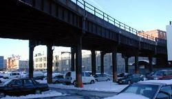
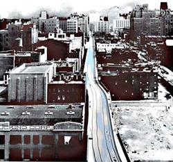
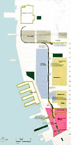
The High Line runs for 1.45 miles over Manhattan’s West Side, from 34th Street down through Chelsea to Gansevoort Street in the Meat Packing District. The High Line was built during one of New York City’s largest infrastructure projects, the West Side Improvement project. The project took place in the early 1930’s during the Great Depression and was presided over by Robert Moses. The Line carried freight above the streets of the West Side until 1980, when the last boxcars hauled a load of frozen turkeys down the tracks. The structure has been inactive since, collecting trash, shedding rust, and sprouting an elevated garden of weeds and wildflowers. [more history here]
In 1992, the Chelsea Property Owners, a coalition of two dozen businesses who own property under and near the Line — mostly parking lots, machine shops, warehouses, and the trendy Chelsea Market — won a conditional demolition order from the Surface Transportation Board. The proposal to tear down the Line was later supported by Mayor Giuliani. The plan never materialized because the coalition and the railroad’s owner at the time, Conrail, could not agree on an ultimate price tag for demolition. [source]
Through the economic boom of the 90’s, however, new residents moved into the neighborhoods below the Line, among them artists, designers, and galleries. In 1999, an altogether different group of neighborhood residents founded Friends of the High Line, a 501(c)(3) non-profit organization with the mission of converting the structure to an elevated public space.
 And, after much lobbying, it looks like the High Line might actually be redesigned. At the July 9 benefit preview of the exhibition, New York City Council Speaker Gifford Miller announced a $15.75 million funding commitment for planning and construction. The first $750,000 was allocated in the budget adopted by the New York City Council on June 27.
“The funds can be used for planning, design, and construction costs related to the High Line project during the fiscal year that began July 1. The remainder of the $15.75 million commitment will be allocated to the High Line in the following three fiscal years.
‘The High Line was built during the Depression to invigorate New York’s economy, and it will reinvigorate our City again today,’ said Speaker Miller. ‘As we have learned from our City’s great parks, public spaces create value and catalyze growth. Central Park was planned in a recession. Even in tough economic times, we have to invest in our future—by planning for the public projects that will keep us at the forefront of the world’s great cities.’
The funds will come from the City’s capital budget, which pays for project costs such as planning, design, construction, and long-term leases. The allocation will not affect municipal services, which are funded separately through the City’s expense budget.” [source]
 The Friends of the High Line are also seeking private, corporate, foundation, and federal funds for the project.
The competition follows two detailed planning studies: Reclaiming the High Line, sponsored by Friends of the High Line and the Design Trust for Public Space; and a comprehensive economic feasibility study, commissioned at the City’s request.
In December 2002, the City of New York took the first step in converting the High Line to a public walkway through federal rails-to-trails legislation. FHL is currently waiting on decision before Federal surface transportation board to allow City to move forward.
“As the next phase in its project to preserve and re-use the High Line, Friends of the High Line will hold a series of open workshops with members of the community beginning in September, with a variety of the competition proposals serving as springboards for discussion. At the end of 2003, Friends of the High Line will incorporate the community’s comments into a Request for Proposals, which will lead to the development of realizable designs.” [source]
The High Line is currently private property, owned by the rail company CSX Corporation. CSX acquired the High Line when it purchased Conrail in 1997. Conrail was created by the federal government in 1970’s from the remains of the New York Central and other railroads bankrupted by “competition from trucks, subsidized by the federally-built Interstate highway system, and an archiac system of economic regulations which prevented railroads from responding to the needs of the market.” The corporation was sold to the public in 1987, in what was then the nation’s biggest IPO. [more on Conrail] Though the High Line is private property, the federal government, specifically the Surface Transportation Board, has control over the Line as a piece of the nation’s rail infrastructure. CSX has been ordered by the government to work with all interested parties to effect the best exit strategy for the High Line, and to remain neutral as to the High Line’s outcome.
The City can not afford to purchase land under High Line, so has instead proposed rezoning and property transfer, moving air and development rights out to sites around West Chelsea. One potential consequence would be a wall of huge residential towers springing up along 10th and 11th Avenues in otherwise moderately sized manufacturing and retail zones. One challenge faced by city planners is the prevention such “massing.”
The High Line snakes through many neighborhoods and buildings, but sits almost entirely within the area served by Manhattan Community Board No. 4. The current Line blocks sunlight, collects trash, and drops water, rust, and pigeon droppings on the streets below. However, according to a survey by the Board, most community residents support conversion over demolition. They want to make sure, though, that the results of the redesign are the best damn park possible. The community is wary of new large-scale structures or billboards that would block sight of or access to the Hudson River. The project should provide open space for cultural programing, be accessible, and safe, providing a way to get up or down quickly. But most of all, it should connect with and respect the community. Some residential buildings sit within 5 feet of Line.
As development proceeds, areas beneath and adjacent to High Line will become lucrative spots for retail. Indeed, represenatives of our businessman-turned-Mayor is keen to move some of that retail up onto High Line itself. Other possibilities include constructing adjacent buildings with roof access that would meet the High Line or produce huge urban stairs, parks that terrace up to the bed of High Line, which is about 30 feet from the ground.
At a panel discussion, I asked Robert Hammond, co-founder of Friends of the High Line, about their advocacy strategy and how design competition fits into it. The competition took a year to organize from beginning to end and was a way to get people excited, to generate activism and support, and to provide a public platform for discussion. He noted the power of crazy, weird ideas - and how it is often easier to draw attention and support for the crazy ideas than the conservative plans. Another panelist noted that, when not located to a specific neighborhood, the constituency of public open space is transient and often does not have a consistent voice. The competition was an opportunity “to get those ideas out there.” Over the years, many have developed redesigns of the High Line for their thesis projects.
I asked Mr. Hammond what has led to their success to date while civic budgets are being cut and other projects around the city have faltered. Mr. Hammond proposed that the support base was “not the usual mix of neighborhood advocates.... The strongest supporters are architects, artists, art dealers.” Indeed a list of supporters at the gala benefit includes many A-list authors, actors, and artists. Not your usual city planning scene.
Mr. Hammond also noted that the design of their campaign materials was also key. Several designers have donated services to develop graphically sophisticated materials. Brochures, Web site, postcards for public comment... “Everything produced looks interesting. It suggests that the final design will be as innovative.”
Ironically, development of the High Line may push many in the arts community to leave the area. When the project is complete, rents around the Line are likely to increase. Many arts spaces are already midway through their 10 year lease, and unable to afford the current market rents. Part of the development plans could create public spaces that would not command retail rents and could support galleries, though these would be limited.
So how will the crazy ideas not get lost, or bogged down by politics? And allow ultimate designer to maintain poetic vision? The challenge is yet to come. Once New York realizes that the project is possible, everyone will want a piece of the action. It will be important to maintain a clear vision, and to make sure the final product is as extraordinary, interesting, and strange as the High Line itself.
Check out these photo galleries on the current state of the High Line.
The High Line was mentioned here in one of my first blog posts.
Rails to Trails
If you’ve ever stood in line at 1am on West 27th street in Manhattan, chances are you’ve noticed an old elevated rail. The High Line was built in the 1930s to elevate dangerous and congesting railroad traffic above city streets. It runs for 1.45 miles, from 34th Street along the edge of the Hudson River through West Chelsea into the Meat Packing District. The Friends of the High Line are dedicated to the preservation of the structure and its conversion into a public park and trail.