Data Visualization & Infographics
A People's Guide to New York City
Antipsychotics in U.S. Nursing Homes
Calendar of Killings by Police
Conflict Dynamics around Refugee Settlements in Northern Uganda
Data Visualization and Human Rights
Executions and disappearances in Punjab
Gold Trade in the Democratic Republic of Congo
Human Rights Watch World Report 2005
Journalists Imprisoned in China
Kardze Tibetan Autonomous Prefecture
Nigeria School Attacks Timeline
Policing Poverty and Racial Inequality in Tulsa
Selected CIA Aircraft Routes and Rendition Flights 2001-2006
Stephens, Catherwood, and Katz
Timeline of Boko Haram Abductions
Visualizing Data for Human Rights Advocacy
Visualizing Information for Advocacy: An Introduction to Information Design
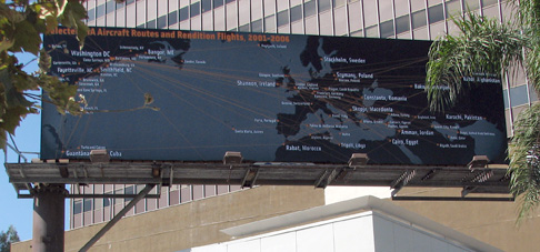
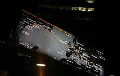
Selected CIA Aircraft Routes and Rendition Flights 2001-2006
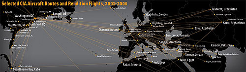
The image is a map of selected CIA aircraft routes between 2001 and 2006, some of which transported prisoners to foreign countries to be interrogated and tortured.
I worked with artist and geographer Trevor Paglen who provided the data. Trevor spent several years tracking down the flight information, and has a book out on his investigations, Torture Taxi: On the Trail of the CIA’s Rendition Flights. See this interview with him on Democracy Now! with co-author, journalist A.C. Thompson.
The map was also published in An Atlas of Radical Cartography, Domus magazine as was displayed at MoMA PS1 and as a public billboard in Los Angeles in September 2006 as part of a series of public art installations about the war. Clockshop, a public arts organization in Los Angeles, funded the display.