

public space
Cut and Paint
Cut&Paint is a zine of stencil templates, ready to cut, ready to paint.
Volume two is in the works with a deadline for submissions on February 20, 2006. In addition to stencils, the issue will include a how-to section, photos of stencils on site, and articles on stenciling, public space, and politics. Check the submission criteria.
The first issue is nearly sold out of its run of 400 copies, so I helped the team post the stencils online. It’s a quick and basic site for now, but will evolve as we add more images. The first 41 stencils are up and ready for download at http://cutandpaint.org.
Quickies
Danish anti-war posters hit Iraq:
“On Friday, Iraqis started hanging over 1000 posters created by the artists in the most populous and important quarters of the capital, including the diplomatic Green Zone in the very heart of the city. Artist Claus Rohland, 50, explained to Aljazeera.net why he and fellow artist Jan Egesborg, 40, had got involved and what message they hoped to send to ordinary Iraqis.... ‘We as Danes are part of this so-called coalition and are taking part in this war. But Denmark is a very small country that has not been at war for many years. We need to question what we are doing and what is happening,’ Rohland said. ‘None of the warring parties — neither US-led forces nor Iraqi rebels — present a solution to this war. The ultimate solution needs to come from ordinary people. It may sound naive, but we would encourage people to keep faith in themselves that a final solution rests with them.’”
---
North Dakota has no plans to alter Sioux logo:
“The NCAA considers the logo and nickname ‘hostile and abusive,’ and has ordered the school to cover up all Fighting Sioux references for the NCAA playoffs. The arena, which operates separately from the school, is holding the West Regional hockey tournament in March. [Jody Hodgson, arena manager,] said there are no plans to alter any logos, which can be found on floors, walls, seats and railings. Eliminating them would be too expensive, he said.”
---
Electronics industry urges federal e-waste action:
“A nine-member panel appearing before the U.S. House of Representatives subcommittee on environment and hazardous materials expressed concern that the current trend of varied state and local laws targeting e-waste management would breed inefficiency, confusion and higher prices for consumers.... The best approach, [Renee St. Denis of Hewlett-Packard] said, is for federal lawmakers to create a system in which the manufacturers themselves set up recycling programs and bear the necessary costs.”
---
Deal for Public Toilets in New York City. Only 20 toilets, but it’s a start. The winning company will rebuild all city newsstands and bus shelters, too — and sell the ad space. Not sure how I feel about a private corporation owning all that public space — but then the NYC gov pays nothing. More on the the long history of trying to build public toilets in NYC here and here.
---
Alcaldía favorece proyecto de biogas. Nicaragua’s biggest garbage dump in the Barrio La Chureca in Managua could be used to create enough electricity to illuminate the nearby municipality of Ciudad Sandino. The joint U.S.-Nicaraguan company Conjuris says they can create four megawatts of electrical energy from the gases emitted by burning the garbage. The company is willing to invest US$5.25 million in the project in return for a twenty year contract.
---
It’s great to see graphic designers come together at displaceddesigner.com, the AIGA, and Design Observer to help other graphic designers affected by Hurricane Katrina. I’m all for community and solidarity. But then it’s really not the professional designers that are hurting the most, no?
---
Only one more month until the October 31 deadline to submit your radical graphics to Reproduce & Revolt. And it looks like Favianna has joined the project!
Call for Entries: Land and Globalization
Via Visual Resistence I found this call for entries:
“SAW (Street Art Workers) is seeking posters for an international street art campaign about land and the effects of globalization. We want you to design and submit posters that will be printed and wheatpasted in cities across Europe and North America. The strongest designs will be published as a mass produced, newsprint poster collection. This will be a 24 page, 2-color newspaper which will include up to 30 posters. SAW will pay for the printing, and volunteers will distribute the posters. The majority of posters will be wheatpasted in public by participating artists and folks who just want to paste up their city.
Based in the U.S., SAW is a network of printmakers, stencil artists, graffiti writers and painters who use the streets for art and activism. We are taking back our cities and towns from the businessmen, cops and politicians who define public space for their own benefit. As a volunteer-run group, we make street art for political campaigns and post each other’s work across North America. Since 2001, our projects have talked about prisons, the mass media and utopian ideas for the future.
We want posters that build connections between international struggles and actual organized projects with high profile publicity. We especially want to see multilingual submissions and work from the perspective of women, Third World communities and indigenous/First Nations. We suggest that artists collaborate with grassroots, social change organizations of their choosing to make posters. We want posters that are both imaginative and relevant to “on the ground” organizing around issues of land, housing and globalization. Working with an organization is not required, but it is encouraged.
It could be argued that Christopher Columbus began our current age of globalization when he washed up on the shores of the New World. The slave trade, imperialism and resource theft that followed in Asia, Africa and America were a brutal beginning for globalization. Today imperial conquest has been refined into cold, impersonal corporate bureaucracies. In the last 30 years these corporations have become economic giants more powerful than many countries. Setting up global assembly lines, today’s corporations move freely around the world forcing countries, rich and poor, to surrender their land, resources and labor. In the process, corporations have made massive profits shifting wealth from the global south to the industrialized north, from the impoverished and working people to the rich and powerful.
SAW wants to look at how this form of globalization has affected our lands and how people are fighting back. How has it affected land in the cities — especially housing? How has globalization impacted land and workers in the countryside with farming, mining, drilling, logging and other resource extraction? What are the connections between land struggles in the global south, indigenous nations and the industrialized north? What are some of the connections between the landless peasants movement of Brazil and the squatter movements of Europe and North America? What links together the struggle against dams in India, hydroelectric projects Canada and water privatization in Latin America and South Africa? How are farmers and campesinos resisting industrial agriculture, like biotechnology and GMOs (genetically modified foods), in the U.S., Mexico and India? What organizing strategies have worked and hich ones have failed? These questions are a starting point. We want to see more questions from you and some hard-hitting answers. We want powerful ideas and inspirational art that we can broadcast directly to the streets in 2005.”

The deadline for submissions is September 1, 2005.
For more info, visit streetartworkers.org
Support Our Tropes

Those little yellow magnets seem to be everywhere. Not quite posters, it’s a regular grassroots movement of car signage, marking the public space in the bumper-to-bumper gaps between the private. (And what better place to support a war for oil?)
The NY Times has a brief story on the origins of the current magnet ribbon, while Design Observer digs up a broader history of the yellow ribbon symbol.
Since the civil war, the ribbon has been used to welcome home loved ones who had been away at war or in prison. The popular 1973 song was loosely based on the story of a soldier returning home from the Civil War. It was a number one hit in April 1973, at the height of the Vietnam War — a time when many veterans ambled to a less than friendly welcome.
But the meaning of the yellow ribbon has shifted over time. Do the current ribbons encourage support of those broken and maimed veterans showing up at homeless shelters? I presume not. I read the symbol as more than just a welcome home, but sign of “loyalty,” not just a show of concern for U.S. soldiers at war, but to admonish those who are not sufficiently supportive — for instance, who oppose the war.
Which is why I’m inclined towards the more specific version produced by United for Peace and Justice:

And the more oppositional styling of the duct tape version:

See also previous posts on freeway posters, orange, red, and blue ribbons.
The Violence of Planning (and Its Resistance)
From Adrian Blackwell and Kanishka Goonewardena, Poverty of Planning: Tent City, City Hall and Toronto’s New Official Plan, in Planners Network, Winter 2003:
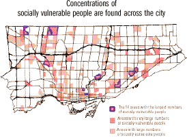 “While the [new official plan of the city of Toronto] represents a victory for the ruling classes of Toronto... some of the background documents prepared for the plan reveal traces of a struggle, even within City Hall. Toronto at the Crossroads, for example, includes a crystal clear map of the concentrations of ‘socially vulnerable areas’ in the city. It illustrates the growing economic polarization and pockets of poverty that form a ring running through the outer suburbs and around the inner city. Any reasonable official plan aiming to build a sustainable and equitable urban life would have started with these realities — the majority of existing people in the city — rather than banking on an exodus of dot.com millionaires and other pipe dreams of the ‘knowledge economy.’
The urgent question is this: What will happen to the various socially vulnerable groups in the city whose neighborhoods are either ignored in this plan or earmarked for gentrification?
The plan actually paves the way to remove people from strategic downtown neighborhoods, concentrating poverty in high-density suburban spaces whose reality is deliberately hidden in its three-lens vision. Complementing this violence of eviction is the alienating physical and symbolic violence constantly inflicted on individuals forced to live in these suburban spaces. These have a number of real effects.
- The physical distance between social classes protects affluent people from the violent power and frustration that economic exploitation creates.
- The physical separation prevents middle- and upper-class Torontonians from experiencing poverty firsthand, allowing them to indulge a fantasy of equality, while breeding stereotypes about people they don’t have to interact with everyday.
- Separation organizes the city so that affluent people have much better access to not only luxury goods, but also to essential services like healthy food, a clean environment, healthcare, public transportation, parks, public spaces and jobs.
- Isolation atomizes the very communities that could otherwise create unified resistance to this alienating condition. One of the lasting legacies of Toronto’s high-density modernist housing is that people are both concentrated and isolated from one another at the same time.
Real separation and isolation are symbolically overcome in the image of the beautiful city. The objective of urban design here is to mask beneath the spectacle of dazzling urban space the potentially explosive realities of the new amalgamated city of developers, taxpayers and global capital.”
The authors are members of Planning Action:
“A group of urban planners, architects and activists who work with diverse communities of Toronto struggling against economic, cultural, and ecological injustice to open spaces for people to imagine, transform, and enjoy the city.”
Their objectives:
- To collaboratively promote social and environmental justice by planning for affordable housing, food, public transportation, public space and accessible education and recreation for all residents and workers of the city.
- To democratize planning practice to foster greater participation and control over the creation and maintenance of the city.
- To build an organization that is committed to radically democratic and socially just practices within its own operation, in its partnerships and collaborations, as well as in the city.
Their work includes:
- popular education and outreach;
- planning, design, and advocacy for individuals and communities marginalized from traditional planning and legal systems;
- promotion of participatory planning that creates alternatives to municipal, competitive, and corporate-driven planning practices; and
- public comment and criticism of development projects, international trade agreements, and city practices, plans, policy, and processes.
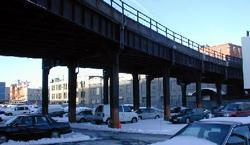
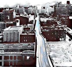
Redesigning the High Line
“Designing the High Line” is an exhibition of ideas for the conversion of the High Line elevated rail structure to public space. The exhibit is showing in Grand Central Terminal until July 26. 720 entries were submitted from 36 countries. More than 100 of the proposals, including the competition winners, are displayed in the Grand Central exhibit. All 720 entries are displayed on the Web site.
In addition to the four principal winners, designs were selected for special cash awards for depicting the most compelling solution for universal access to the elevated structure, and for incorporating plants and wild flowers native to New York. (Pictures are posted here and here, though difficult to read.)
The High Line runs for 1.45 miles over Manhattan’s West Side, from 34th Street down through Chelsea to Gansevoort Street in the Meat Packing District. The High Line was built during one of New York City’s largest infrastructure projects, the West Side Improvement project. The project took place in the early 1930’s during the Great Depression and was presided over by Robert Moses. The Line carried freight above the streets of the West Side until 1980, when the last boxcars hauled a load of frozen turkeys down the tracks. The structure has been inactive since, collecting trash, shedding rust, and sprouting an elevated garden of weeds and wildflowers. [more history here]
In 1992, the Chelsea Property Owners, a coalition of two dozen businesses who own property under and near the Line — mostly parking lots, machine shops, warehouses, and the trendy Chelsea Market — won a conditional demolition order from the Surface Transportation Board. The proposal to tear down the Line was later supported by Mayor Giuliani. The plan never materialized because the coalition and the railroad’s owner at the time, Conrail, could not agree on an ultimate price tag for demolition. [source]
Through the economic boom of the 90’s, however, new residents moved into the neighborhoods below the Line, among them artists, designers, and galleries. In 1999, an altogether different group of neighborhood residents founded Friends of the High Line, a 501(c)(3) non-profit organization with the mission of converting the structure to an elevated public space.
 And, after much lobbying, it looks like the High Line might actually be redesigned. At the July 9 benefit preview of the exhibition, New York City Council Speaker Gifford Miller announced a $15.75 million funding commitment for planning and construction. The first $750,000 was allocated in the budget adopted by the New York City Council on June 27.
“The funds can be used for planning, design, and construction costs related to the High Line project during the fiscal year that began July 1. The remainder of the $15.75 million commitment will be allocated to the High Line in the following three fiscal years.
‘The High Line was built during the Depression to invigorate New York’s economy, and it will reinvigorate our City again today,’ said Speaker Miller. ‘As we have learned from our City’s great parks, public spaces create value and catalyze growth. Central Park was planned in a recession. Even in tough economic times, we have to invest in our future—by planning for the public projects that will keep us at the forefront of the world’s great cities.’
The funds will come from the City’s capital budget, which pays for project costs such as planning, design, construction, and long-term leases. The allocation will not affect municipal services, which are funded separately through the City’s expense budget.” [source]
 The Friends of the High Line are also seeking private, corporate, foundation, and federal funds for the project.
The competition follows two detailed planning studies: Reclaiming the High Line, sponsored by Friends of the High Line and the Design Trust for Public Space; and a comprehensive economic feasibility study, commissioned at the City’s request.
In December 2002, the City of New York took the first step in converting the High Line to a public walkway through federal rails-to-trails legislation. FHL is currently waiting on decision before Federal surface transportation board to allow City to move forward.
“As the next phase in its project to preserve and re-use the High Line, Friends of the High Line will hold a series of open workshops with members of the community beginning in September, with a variety of the competition proposals serving as springboards for discussion. At the end of 2003, Friends of the High Line will incorporate the community’s comments into a Request for Proposals, which will lead to the development of realizable designs.” [source]
The High Line is currently private property, owned by the rail company CSX Corporation. CSX acquired the High Line when it purchased Conrail in 1997. Conrail was created by the federal government in 1970’s from the remains of the New York Central and other railroads bankrupted by “competition from trucks, subsidized by the federally-built Interstate highway system, and an archiac system of economic regulations which prevented railroads from responding to the needs of the market.” The corporation was sold to the public in 1987, in what was then the nation’s biggest IPO. [more on Conrail] Though the High Line is private property, the federal government, specifically the Surface Transportation Board, has control over the Line as a piece of the nation’s rail infrastructure. CSX has been ordered by the government to work with all interested parties to effect the best exit strategy for the High Line, and to remain neutral as to the High Line’s outcome.
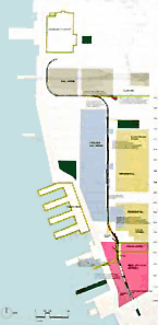
The City can not afford to purchase land under High Line, so has instead proposed rezoning and property transfer, moving air and development rights out to sites around West Chelsea. One potential consequence would be a wall of huge residential towers springing up along 10th and 11th Avenues in otherwise moderately sized manufacturing and retail zones. One challenge faced by city planners is the prevention such “massing.”
The High Line snakes through many neighborhoods and buildings, but sits almost entirely within the area served by Manhattan Community Board No. 4. The current Line blocks sunlight, collects trash, and drops water, rust, and pigeon droppings on the streets below. However, according to a survey by the Board, most community residents support conversion over demolition. They want to make sure, though, that the results of the redesign are the best damn park possible. The community is wary of new large-scale structures or billboards that would block sight of or access to the Hudson River. The project should provide open space for cultural programing, be accessible, and safe, providing a way to get up or down quickly. But most of all, it should connect with and respect the community. Some residential buildings sit within 5 feet of Line.
As development proceeds, areas beneath and adjacent to High Line will become lucrative spots for retail. Indeed, represenatives of our businessman-turned-Mayor is keen to move some of that retail up onto High Line itself. Other possibilities include constructing adjacent buildings with roof access that would meet the High Line or produce huge urban stairs, parks that terrace up to the bed of High Line, which is about 30 feet from the ground.
At a panel discussion, I asked Robert Hammond, co-founder of Friends of the High Line, about their advocacy strategy and how design competition fits into it. The competition took a year to organize from beginning to end and was a way to get people excited, to generate activism and support, and to provide a public platform for discussion. He noted the power of crazy, weird ideas - and how it is often easier to draw attention and support for the crazy ideas than the conservative plans. Another panelist noted that, when not located to a specific neighborhood, the constituency of public open space is transient and often does not have a consistent voice. The competition was an opportunity “to get those ideas out there.” Over the years, many have developed redesigns of the High Line for their thesis projects.
I asked Mr. Hammond what has led to their success to date while civic budgets are being cut and other projects around the city have faltered. Mr. Hammond proposed that the support base was “not the usual mix of neighborhood advocates.... The strongest supporters are architects, artists, art dealers.” Indeed a list of supporters at the gala benefit includes many A-list authors, actors, and artists. Not your usual city planning scene.
Mr. Hammond also noted that the design of their campaign materials was also key. Several designers have donated services to develop graphically sophisticated materials. Brochures, Web site, postcards for public comment... “Everything produced looks interesting. It suggests that the final design will be as innovative.”
Ironically, development of the High Line may push many in the arts community to leave the area. When the project is complete, rents around the Line are likely to increase. Many arts spaces are already midway through their 10 year lease, and unable to afford the current market rents. Part of the development plans could create public spaces that would not command retail rents and could support galleries, though these would be limited.
So how will the crazy ideas not get lost, or bogged down by politics? And allow ultimate designer to maintain poetic vision? The challenge is yet to come. Once New York realizes that the project is possible, everyone will want a piece of the action. It will be important to maintain a clear vision, and to make sure the final product is as extraordinary, interesting, and strange as the High Line itself.
Check out these photo galleries on the current state of the High Line.
The High Line was mentioned here in one of my first blog posts.
Designing Supportive Housing
From an April 2002 interview in Metropolis Magazine:
“Rosanne Haggerty is the new landlord of the Andrews Hotel, a grim vermin-infested joint at the corner of Bowery and Spring Street on Manhattan’s Lower East Side. She is also founder and executive director of Common Ground Community, a nonprofit organization that has purchased and converted a handful of historic buildings, including the Times Square Hotel, into some of New York’s most progressive low-income housing — work that last year earned her a $500,000 ‘genius grant’ from the MacArthur Foundation.
After four years of field research that took Haggerty and her staff from the public shelters of New York to the capsule hotels of Japan, Common Ground Community is set to begin transforming the century-old Andrews into something they call First Step Housing. Working with New York architects Marguerite McGoldrick and Gans + Jelacic, and more than 150 homeless men and women who contributed feedback, Haggerty plans to combine elements of the Bowery’s dying flophouse tradition — $7 a night, no lease, no questions — with smart management, on-site social services, and space-efficient modular design. Recently she spoke with Douglas McGray about the project’s design considerations — and its lessons.”
Rosanne Haggerty:
“Social scientist Christopher Jencks zoned in on the loss of the cubicle hotels as a specific cause of the rise of single-adult homelessness. That got me thinking, Why don’t these places exist anymore? For years I’d get close to the question and then recoil because these buildings were so squalid. The quality-housing advocate in me couldn’t comprehend how one could responsibly advocate their resurgence. It finally occurred to me that until not-for-profits started working on them, single-room occupancies had also been looked at as substandard forms of housing. Then it clicked — it’s more of a failure of imagination on our part than anything embedded in the model.”
After extensive research, including two months in Osaka, Japan studying the flexible use of limited space, interviews with individuals and groups of homeless men and women, including feedback on three rounds of prototypes, Common Ground developed a design that was attractive, affortable, and secure.
“The main reason people are remaining on the streets is safety. They perceive themselves to be more secure sleeping in a public space than in the city’s shelter system. People were very keen on the idea of metal detectors, very concerned about what the roof material would look like — how secure it would be. They were concerned about the strength of the lock and the durability of the construction....
Somebody had a very good line. He said, ‘You don’t want it to be a doll house, but you don’t want it to be a cell either.’ A lot of these folks have been in psychiatric hospitals or in jail, and they don’t want an environment that reminds them of that. Things as subtle as being able to move the furniture around — not having it nailed down — being able to get control of a degree of privacy in the space, having a window that opens and closes onto a central corridor seemed to take something that could have been viewed as institutional and make it cozy....
Frankly, design makes a significant difference in terms of the atmosphere of calm and respect that you establish. People respond behaviorwise to being in that kind of environment. Keeping maintenance costs reduced is also a consideration. We need spaces that can be cleaned easily, panels that can be removed and replaced without having to trash the whole unit.”
The First Step units are prefabricated, ship nearly flat and can bolt together in almost any commercial space.
Many of the housing projects incorporate social services:
“Supportive housing is permanent housing with social services for the formerly homeless, people with mental and/or medical disabilities, the elderly, and individuals with low-income. Supportive housing combines affordable accomodations with services like mental health and drug addiction counseling, job training and placement, community activities, and help with life skills like cooking and money management.
Supportive housing was created by non-profits around the country as a more holistic response to homelessness. Approximately 70% of homeless single adults in the United States have problems like mental illness, substance abuse and HIV/AIDS — problems which contribute to their homelessness. By offering a variety of support services designed to address these issues, supportive housing has paved the way for a more effective approach to preventing homelessness....
Two long-term government studies have shown that more than 83% of the homeless individuals placed in supportive housing have remained in permanent housing and have reintegrated themselves into mainstream society.”
See the Corporation for Supportive Housing and the Supportive Housing Network of New York.
Common Ground and the Architectural League of New York are currently running an open competition to design a new “prefabricated individualized dwelling unit.” The registration deadline is July 11, 2003. The design entry submission deadline is 10 AM, August 25, 2003.
“Up to four competition winners will be chosen. Winners will each receive a cash prize of $2,000 and will be engaged to develop their proposals for manufacture and installation at the Andrews House, a lodging house on the Bowery in Manhattan, for which they will be paid a design fee. An exhibition of entries will be mounted in Manhattan in October 2003, and displayed on the competition website. A publication documenting the competition may also be produced.”
See the First Step Housing Web site for more detail.
Under the Asphalt, the Cobblestones
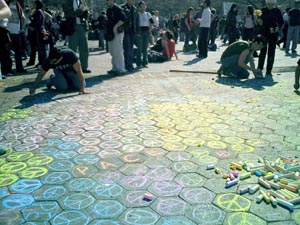
Protestors after the march in New York City yesterday chalked messages around Washington Square Park.
As the U.S. invades Iraq and activists around the world take to the streets, here in New York I’m noticing how the city itself is increasingly used as a medium by the anti-war movement.
 Much of this is nothing new. City streets have always been checkered with posters, graffiti, flyers, and stickers. Subway ads are often annotated with running commentary, sometimes sexual but just as often critical of the ad and advertiser itself (or just blacked out teeth on a too-cheerful model.)
 The anti-war movement has taken advantage of all of this. United for Peace and Justice stickers seem to be everywhere — on pay phones, mailboxes, street lamps, walls, and signage. The letters “STOP BUS” on the street are altered to read “STOP BUSH.” In the Baghdad Snapshot Action activists have simply postered ordinary snapshots from Iraq: “Quiet and casual, the snapshots show a part of Baghdad we rarely see: the part with people in it.”
And then there was the march of over 200,000 people down midtown Manhattan yesterday.
But as the war escalates, so do the protests. And so does the reconfiguring of public space. Activists in San Francisco last week shut down traffic throughout the city with autonomous direct actions coordinated online. Activists hauled newspaper kiosks, cafe chairs and tables, and other street furniture into the streets. [article and photos]
What will be the government’s response? Some communities are all too familiar with locked down, fenced in, and video monitored public spaces. Once considered an invasion of privacy, cameras and other measures are increasingly justified as a legitimate response to terrorism. In the name of anti-terrorism, the City recently sought and won a loosening of the law that restricted on police surveillance of political groups. The restrictions were imposed by the settlement of a 1971 lawsuit over harassment of political advocacy groups by the Police Department’s so-called “Red Squad.”
Public amenities and the details of public life are being reshaped elsewhere in the fight against terrorism. In Israel, seating at bus stops is often bolted to the wall (no chair legs to hide things behind), every turnstile will soon have a metal detector installed, and every trash can on the street will be replaced with see-through plastic and wire receptacle. In Washington, D.C., subway trash cans are being replaced with bomb-resistant models. In the Tokyo subway, there are no trash cans at all anymore.
Not to mention Israel’s wall.
This week New York City announced Operation Atlas, additional security measures to try to protect us against terrorist attack during wartime. I’m not opposed to greater inspection of cargo entering the City, but have no doubt that the NYPD will use their new powers to target activists and political dissent. I also note that the plan, which costs $5 million a week comes at a time of severe budget cuts in NYC — and a deficit of nearly $4 billion. Was factored into the costs of the war?
Literature on cities is replete with the metaphor of public space as the site and the physical embodiment of democracy. In the weeks and months ahead, I wonder how our public space will change.
See NYC IndyMedia and Gotham Gazette’s page on New York City and the War.
Printer Drivers
Two projects from the Institute for Applied Autonomy:
“GraffitiWriter is a tele-operated field programable robot which employs a custom built array of spray cans to write linear text messages on the ground at a rate of 15 kilometers per hour. The printing process is similar to that of a dot matrix printer. GraffitiWriter can be deployed in any highly controlled space or public event from a remote location.” See also instructions on how to build your own.
“The StreetWriter project expands on the research gained from the successful Robotic GraffitiWriter project. The system consists of a custom built, computer controlled industrial spray painting unit that is built into an extended body cargo van. The vehicle prints text messages onto the pavement in a manner much like a dot-matrix printer. The expanded width of StreetWriter allows for messages and simple graphics that are legible from tall buildings and low flying aircraft and is capable of rendering message that are several hundreds of feet in length.” Lots of pix and videos at both sites.
See also Bike Writing, a project to turn any bicycle into a printing, street writing device that prints as you ride.
“The bike writer incorporates interchangeable rubber stamps into the wheels so that while riding, the user can inscribe text into public space. An ink roller is applied to the wheel through a simple mechanism, which is activated by squeezing the rear break handle. This activity is extremely covert and effective.”
Mapping Manhattan Surveillance
For the exhibition “We Love New York: Mapping Manhattan with Artists and Activists,” the Institute for Applied Autonomy and the Surveillance Camera Players led workshops on surveillance cameras, public space, and civil liberties. Participants then took to the streets to document the city’s surveillance cameras. The findings were mapped onto an 80 foot map of Manhattan. The group also led walking tours of the City. “Participants [moved] through the city in small groups, using handheld devices to document surveillance camera locations. The cameras will be added to the iSEE community database that allows pedestrians to track the ‘path of least surveillance’ between any two points in Manhattan.”